What Is Happening Below the Surface During an Earthquake Now
Learn how an earthquake now works, why tectonic plates move, and how scientists track tremors around the world using real-time data.
The ground beneath your feet feels solid, but it is actually moving all the time. Right at this very moment, sections of the earth are shifting, rubbing together, and breaking. When you hear about an earthquake now, it is the result of sudden energy releases that have been building up for decades. Understanding an earthquake now requires us to look past the surface shaking and explore the deep geology that drives these powerful events. By studying the mechanics of the earth, readers can learn exactly why our planet tremoves and how new technology tracks these vibrations as they happen.
The deep science behind an earthquake now
To understand an earthquake now, you have to look at the outer shell of the earth. This shell is not one solid piece like a glass marble. Instead, it is broken into giant puzzle pieces called tectonic plates. These plates float on a hot, semi-solid layer of rock underneath them. Because this deep rock moves slowly, the giant plates on top are forced to move too, usually traveling just a few inches every single year.
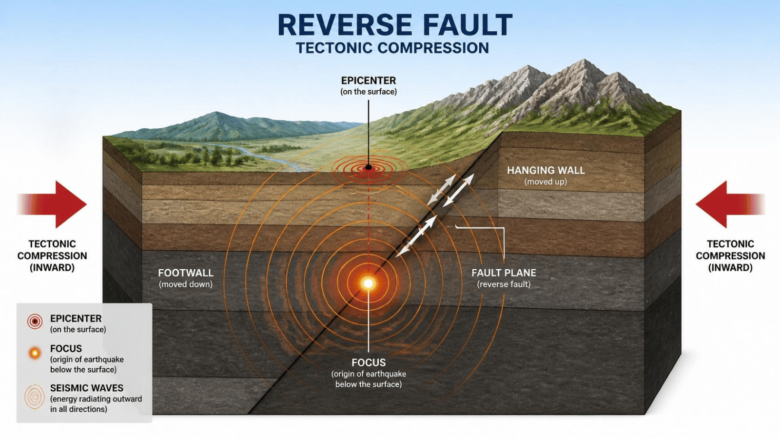
As these plates move, their rough edges get stuck against each other. Even though the edges are locked in place, the rest of the plate keeps pushing forward. This action creates a massive amount of stress along the border, which scientists call a fault line. An earthquake now happens when that stuck rock finally breaks under the pressure, releasing waves of energy that travel straight to the surface.
The exact spot underground where the rock breaks is called the focus. The point directly above it on the surface of the earth is called the epicenter. When a major earthquake now occurs, the energy travels out from the focus in waves, similar to what happens when you drop a heavy stone into a quiet pond. These waves are what cause the ground to shake, buckle, and roll under our cities.
The unique types of shockwaves that shake the ground
How different seismic waves create the motion of an earthquake now
Scientists divide the energy from an earthquake now into two main types of waves that move through the ground at different speeds. The very first wave to arrive is called a primary wave, or P-wave. This wave squeezes and stretches the underground rock like an accordion. P-waves are incredibly fast, and they can travel through both solid rock and liquid layers, serving as the first warning sign for electronic sensors.
The second type of wave is called a secondary wave, or S-wave. S-waves move much slower than P-waves and can only travel through solid rock. Instead of squeezing the ground, an S-wave moves the earth up and down or side to side, creating a rolling motion. When a heavy earthquake now strikes a region, the delay between the fast P-wave and the slower S-wave tells scientists exactly how far away the epicenter is located.
There are also surface waves that travel only along the very top layer of the earth. While they are the slowest waves of all, they cause the most violent shaking and do the most damage to buildings and roads. Learning how these different waves behave helps engineers design better structures that can sway safely with the ground instead of breaking apart during a crisis.
How real-time global monitoring networks track the shaking
The global scientific community tracks every single earthquake now using a massive network of sensitive tools called seismographs. These instruments are bolted deep into solid rock all over the world to pick up even the tiniest vibrations. When the ground moves, the base of the machine moves with it, but a heavy weight hanging inside stays completely still, allowing a sensor to record the exact size of the shake.
This data is sent instantly to international research centers like the United States Geological Survey. When a major earthquake now triggers multiple sensors, computers look at the arrival times of the waves to pinpoint the location within seconds. This rapid tracking allows emergency teams to send help to the hardest-hit areas immediately.
Modern technology also uses satellite data to map how the surface of the earth physically shifted after the shaking stops. By comparing satellite images taken before and after the event, scientists can see exactly how many feet the fault line moved. This constant monitoring provides crucial clues that help researchers map out dangerous faults and protect communities before the next big shake occurs.